Link E-Map to Area
You can add and link e-maps to the area so that the elements assigned to the area can be added to e-map.
-
Add a map for an area. Three ways are available for adding e-map.
Option Description Add E-Map When Adding Area
-
Click
 on the area
list panel.
on the area
list panel. -
Set the parameters for adding area.
-
Set the Related Map switch to ON.
-
Hover the mouse over the Map field and link a map for the area.
You can click Upload Picture and select a picture from local PC as the e-map. Or click Existing Map and select an existing map for linking to current area.
-
Optional: Repeat the previous step to add more e-maps for the area.
Add E-Map When Editing Area
-
Select a map and click
 on the area
list panel to enter the area editing page.
on the area
list panel to enter the area editing page. -
Edit the area settings as desired.
-
Set the Related Map switch to ON if it is OFF.
-
Hover the mouse over the empty Map field and link a map for the area.
You can click Upload Picture and select a picture from local PC as the e-map. Or click Existing Map and select an existing map for linking to current area.
-
Optional: Repeat the previous step to add more e-maps for the area.
Directly Link Map to Existing Area
Note:You can adopt this way when the GIS map is not enabled.
-
Click
 to show the
map area.
to show the
map area. -
Click Relate Map for adding and linking map.
-
Select the areas for linking e-maps.
-
Hover the mouse over the Map field and link a map for the area.
You can click Upload Picture and select a picture from local PC as the e-map. Or click Existing Map and select an existing map for linking to current area.
-
Optional: Repeat the previous step to add more e-maps for the area.
Map Scale window will pop up.
-
- Optional:
Set a map scale.
Note:
The scale of a map is the ratio of a distance on the map to the corresponding distance on the ground. The client can calculate two locations' distance on the map according to the distance on the ground. An accurate map scale is essential for defining a radar's detection area. Perform this step if you plan to add a radar to the map.
Figure 1. Edit Map Scale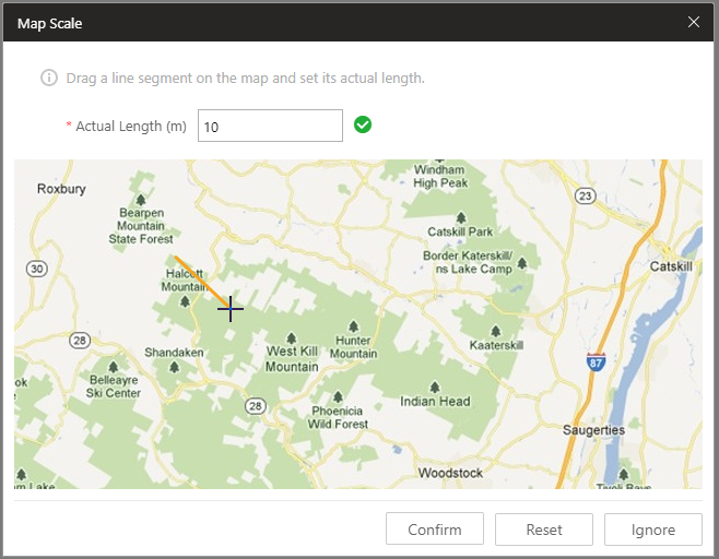
- Click two locations on the map to form a line.
- Enter the real distance between the two points in the Actual Length field.
- Click Confirm to finish setting the map scale.
- Optional:
Perform the following operations after adding map in the map area.
Option Description Filter
Click
 and select the
object type you want to show on the map.
and select the
object type you want to show on the map.Full Screen
Click
 to show the map in
full-screen mode.
to show the map in
full-screen mode.Zoom In/Out
Scroll the mouse wheel or click
 /
/ to zoom in or zoom
out the map.
to zoom in or zoom
out the map.Adjust Map Area
Drag the map or the red window in the lower part to adjust the map area for view.
Link E-Map to Area
You can add and link e-maps to the area so that the elements assigned to the area can be added to e-map.
-
Add a map for an area. Three ways are available for adding e-map.
Option Description Add E-Map When Adding Area
-
Click
on the area
list panel. -
Set the parameters for adding area.
-
Set the Related Map switch to ON.
-
Hover the mouse over the Map field and link a map for the area.
You can click Upload Picture and select a picture from local PC as the e-map. Or click Existing Map and select an existing map for linking to current area.
-
Optional: Repeat the previous step to add more e-maps for the area.
Add E-Map When Editing Area
-
Select a map and click
on the area
list panel to enter the area editing page. -
Edit the area settings as desired.
-
Set the Related Map switch to ON if it is OFF.
-
Hover the mouse over the empty Map field and link a map for the area.
You can click Upload Picture and select a picture from local PC as the e-map. Or click Existing Map and select an existing map for linking to current area.
-
Optional: Repeat the previous step to add more e-maps for the area.
Directly Link Map to Existing Area
Note:You can adopt this way when the GIS map is not enabled.
-
Click
to show the
map area. -
Click Relate Map for adding and linking map.
-
Select the areas for linking e-maps.
-
Hover the mouse over the Map field and link a map for the area.
You can click Upload Picture and select a picture from local PC as the e-map. Or click Existing Map and select an existing map for linking to current area.
-
Optional: Repeat the previous step to add more e-maps for the area.
Map Scale window will pop up.
-
- Optional:
Set a map scale.
Note:
The scale of a map is the ratio of a distance on the map to the corresponding distance on the ground. The client can calculate two locations' distance on the map according to the distance on the ground. An accurate map scale is essential for defining a radar's detection area. Perform this step if you plan to add a radar to the map.
Figure 1. Edit Map Scale
- Click two locations on the map to form a line.
- Enter the real distance between the two points in the Actual Length field.
- Click Confirm to finish setting the map scale.
- Optional:
Perform the following operations after adding map in the map area.
Option Description Filter
Click
and select the
object type you want to show on the map.Full Screen
Click
to show the map in
full-screen mode.Zoom In/Out
Scroll the mouse wheel or click
/ to zoom in or zoom
out the map.Adjust Map Area
Drag the map or the red window in the lower part to adjust the map area for view.