View and Operate Hot Spot
You can view locations of hot spots including cameras, alarm inputs, alarm outputs, access points, elevators, radars, sites, Under Vehicle Surveillance Systems (UVSS), etc. on the map. Also, you can set the arming control and view history alarms of monitoring scenarios through the hot spots. You can view latitude and longitude information and available operations of a certain resource by hovering over a resource on GIS map as well.
Configure the map settings via the Web Client. For details, see Map Management。
-
In the top left corner of Home page, select
 > Visual Map > Map > Map Monitoring.
- Optional:
Perform the following operations on the map.
Option Description Filter Resource on Map
Click
 and check resource
type(s) as desired.
and check resource
type(s) as desired.More Tools
 : Add a label on
map.
: Add a label on
map.2D/3D: Switch the displaying dimension of the map.
 : Search hot spot
or location on the map.
: Search hot spot
or location on the map. -
Click the hot spot to open the dialog which displays its related
functions.
Note:
-
If there is an alarm triggered on the hot spot, the hot spot icon will turn into red alarm mode
 . Click the red
icon, and you can view the detailed alarm information.
. Click the red
icon, and you can view the detailed alarm information. -
Click parking lot data, a panel of parking lot details will pop-up. You can view detailed parking lot information such as parking space occupancy rate and parking floor details.
-
-
Operate in the dialog.
Option Description Arm or Disarm Hot Spot
You can arm or disarm the hot spots via the arming control function. After arming the device, the current Control Client can receive the triggered alarm information from the hot spot.
Click a hot spot to open the dialog which displays its related functions. In the dialog, click Arm/Disarm to arm/disarm the hot spot.
View History Alarm
When an alarm is triggered, it will be recorded in the system. You can check the history log related to an alarm, including the alarm source details, alarm category, alarm triggered time, etc.
Click a hot spot to open the dialog which displays its related functions. In the dialog, click
 to enter the event
and alarm search page. Then you can search history alarms of the hot
spot. See Search for Event and Alarm Logs for details.
to enter the event
and alarm search page. Then you can search history alarms of the hot
spot. See Search for Event and Alarm Logs for details.Broadcast via Hot Spot
You can broadcast via hot spot through real-time speaking or playing the saved audio files.Note:Make sure you have added broadcast resources on the map.
-
On the map, click the broadcast resource to view details such as Status, Area, and Remark.
-
Click Broadcast to select the broadcast mode.
-
Select Speak or Play Audio File as the broadcast mode.
Note:Speak: Speak in real-time, and the audio will be recorded and uploaded to the server.
Play Audio File: Play the files saved in the server. You can search or select a desired audio file to play. You can click Download to download a selected audio file, and the broadcast will be more fluent.
-
Click Start.
-
If you select Speaking, the broadcast will start immediately.
-
If you select Play Audio File, it will start downloading the audio file from the cloud if you choose a cloud file, or to play the audio file immediately if it is a local file.
-
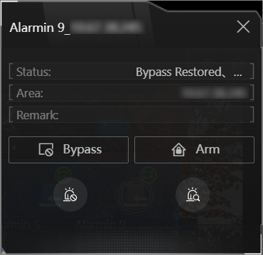 Figure 1 Arm Hot Spot / View
History Alarm
Figure 1 Arm Hot Spot / View
History Alarm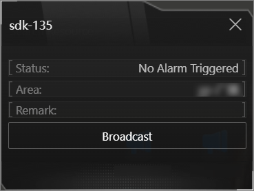 Figure 2 Broadcast via Hot
Spot
Figure 2 Broadcast via Hot
Spot -